Thursday, July 30, 2020

Downeast Camping Trip, Part 2 (Cobscook Bay Area - Cobscook Bay SP, Klondike Mountain, Reversing Falls Preserve, Matthew's Island Preserve)

My older son and I went on a three night camping trip in Washington County this past weekend, visiting a large number of parks, preserves and other points of interest.  This post will cover the section of our trip around Cobscook Bay.

Here is a map of the four preserves that we visited.

Cobscook Bay State Park

We camped all three nights at Cobscook Bay State Park.  The beautiful thing about the park is that due to its unique coastline, it offers a large number of waterfront campsites.  Although primarily a camping park, there are a few trails within the park.  We explored the short (4/10 mile round-trip) but rewarding overlook trail, which leads to the summit of 150' tall Cunningham Mountain.  

View from our campsite
View from summit of Cunningham Mountain.

Klondike Mountain

Located in Lubec, Klondike Mountain is the tallest point on the Lubec peninsula and provides excellent views of the surrounding area.  A short 0.4 mile trail leads to the summit.  The trail is relatively easy except for a very short section near the summit. The preserve is managed by the Downeast Coastal Conservancy; for more information visit its website.


Reversing Falls Preserve

Reversing Falls Preserve is a Downeast Coast Conservancy preserve that features reversing falls, caused by 24 foot tides that run over a huge underwater ledge between the preserve and Falls Island.  The round-trip 1.2 mile forested trail led us to a peninsula with a rocky prominence that provided views of the falls.  For more information visit https://downeastcoastalconservancy.org/dcc-trails/reversing-falls.


Matthew's Island Preserve

Matthew's Island Preserve is a 14 acre preserve accessible during low tide.  We walked 1.4 miles round-trip from the parking lot to the far end of the island and back.  The trail was overgrown with grass in several parts.  We did not have any ticks on us but did find a large number of red ants after our hike.  For more information on the preserve visit https://www.mcht.org/preserve/matthews-island.


Downeast Camping Trip, Part 1 (Coastal Lands from Cutler to Lubec - Quoddy Head State Park, Hamilton Cove Preserve, Boot Head Preserve, Bog Brook Preserve, Cutler Coast Public Reserve Land, Eastern Knubble Preserve)

My older son and I went on a three night camping trip in Washington County this past weekend, visiting a large number of parks, preserves and other points of interest.  This post will cover the coastal part of our trip.

Coastal Preserves

Maine's coastline from Quoddy Head to Cutler is dominated by several publicly accessible preserves that offer dramatic views of sheer rock cliffs, rocky beaches and sweeping views of the Gulf of Maine and the Bay of Fundy.  From north to south, public lands include Quoddy Head State Park, Hamilton Cove Preserve, Boot Head Preserve, Eastern Head, Bog Brook Preserve, Cutler Coast Public Reserve Land, Eastern Knubble Preserve and Western Head Preserve (we didn't visit Eastern and Western Head Preserves).  Each preserve is within 10-20 minutes of the next.

A map containing all six of our hikes is here.

Quoddy Head State Park

Perhaps best known for the iconic West Quoddy Lighthouse, Quoddy Head State Park also has several miles of hiking trails that provide dramatic views of sheer rock cliffs looking out over the Bay of Fundy at Grand Manan Island.

We visited Quoddy Head three times on this trip, for sunset on Friday night and sunrise on Saturday and Sunday mornings.  Our focus each time was capturing the lighthouse during golden hour; however, we did hike 2.6 miles on the coastal trail out to Green Point.  The trail offers excellent views of the park's dramatic sheer cliffs.


Hamilton Cove Preserve

Hamilton Cove Preserve is a 1,225 acre Maine Coast Heritage Trust preserve.  We hiked 3.1 miles on the coastal trail, which starts off through a grass and brush field and then enters a boreal forest until the trail ends at a bench overlooking the ocean.  Along the way, a side trail leads out to an overlook platform.  For additional information see https://www.mcht.org/preserve/hamilton-cove.


Boot Head Preserve

Boot Head Preserve is another Maine Coast Heritage Trust preserve.  The trail leads through a bog and then a coastal forest out to amazing views of the rocky shoreline.   We hiked a total of 2.9 miles.  For more information see https://www.mcht.org/preserve/boot-head.


Bog Brook Preserve

There are two parking areas for MCHT's Bog Brook Preserve - the main lot off of Route 191 and the Moose Cove parking area.  We visited the Moose Cove lot as it provided quick access to the shoreline.  This section of the park has a rocky beach with a number of large rock formations.  A short 0.9 mile hike provided amazing views.  For more information see https://www.mcht.org/preserve/bog-brook-cove.


Cutler Coast Public Reserve Land

Cutler Coast Public Reserve Land is a 12,334 acre preserve with miles of rocky shoreline.  We hiked a small portion of the trails, 3.6 miles roundtrip, from the parking lot to a sheer rock cliff.  For more information visit the state's website here.


Eastern Knubble Preserve

Despite being only 30 acres, Eastern Knubble Preserve in Cutler provides dramatic shoreline views and an opportunity to walk through a coastal forest.  For more information visit https://www.mcht.org/preserve/eastern-knubble.


Sunday, July 19, 2020

Oak Hill Trail, Great Pond Mountain Wildlands (Orland)

My older son and I hiked the Oak Hill Trail and camped out in the Great Pond Mountain Wildlands this weekend.

The Wildlands has two established backcountry campsites.  Reservations can be made through its website at https://www.greatpondtrust.org/wildland-maps-guidelines/using-the-wildlands/.

Oak Hill's summit is approximately 2.4 miles from the south gate. The summit provides views of the the surrounding area and also features low elevation bald habitat, fragile vegetation found in only a few spots in Maine.  Care should be used when at the summit to avoid disturbing the plants.

Friday, July 17, 2020

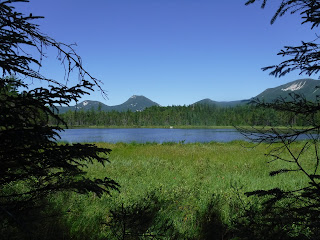
Baxter State Park (West Peak, Ponds Loop, Abol Pond, Daicey Pond, Katahdin Stream Campground)

My younger son and I spent two days and two nights hiking, kayaking and camping at Baxter State Park.  

We started our trip on Wednesday with a four mile hike exploring the ponds west of the Katahdin Stream Campground.   We took the Elbow Trail from the Tote Road and visited Tracy, Elbow, Daicey and Grassy Ponds in hopes of spotting a moose.   We failed to see any moose but did enjoy great views of the nearby mountains.   While relatively easy, the hike involved surprisingly more elevation changes than we had anticipated.  While we has seen a few people on canoes in the ponds, we only encountered two other hikers on the trail.  Here is a map of our hike.


After dinner, we kayaked Abol Pond.  We parked at the Abol Beach Picnic Area.  We stopped here on our way into the park and ate lunch.  The area has a small beach and both times we visited we had it to ourselves.  We paddled two miles around the pond and enjoyed amazing views of Mount Katahdin.


We camped both nights in a lean-to at Katahdin Stream Campground.  The lean-tos are well maintained and fit two backpacking tents inside of them comfortably.   We were located right next to Katahdin Stream, which provided natural white noise all night.   The campground provides a good launching point for those hiking Hunt Trail to Katahdin or The Owl.  The campground was quiet and peaceful both nights.


On Thursday we hiked 5.8 miles round-trip to West Peak off of the Mount OJI trail.  Although it offered few views on the way up, this was a beautiful trail that lead to amazing views once at the overlook.  The trail starts over a series of wooden board bridges, and then continues up through a muddy stream before turning to a regular footpath through the forest and starting the ascent.  The West Peak overlook provided a wide view of the area including the nearby Mount OJI.  Here is a map of our hike.


After the hike we kayaked Daicey Pond.  Like many of the ponds in Baxter, we could have rented a canoe here from the park had we not brought our own kayaks.  We paddled the perimeter, enjoying views of Katahdin and other nearby mountains and spotted a loon, several large tadpoles, and a very friendly frog.


Tadpoles on a rock
More tadpoles