Sunday, February 24, 2019

Dorothea Dix Park in Hampden

Today I went for a brief snowshoeing trek at Dorothea Dix Park in Hampden.  I wanted to get in a quick trip before the snow started falling.

I had driven past this park on a number of occasions but didn't know much about it and didn't expect much.  I was pleasantly surprised as the park has a nice (although unmarked) trail system.

The park is wooded and surrounded by residential development.  The parking area wasn't plowed so I parked on 1A and walked in.  The trails had signage but no trail markings.  I'm assuming that in the warmer months the trails may be obvious but there was no indication of where the trails went as they were covered in snow.  I did follow someone else's tracks for much of the way and was able to hike down near the river.

I did a total of 1.5 miles with only minimal elevation changes.  There were nice although somewhat obstructed views of the river and evidence of deer activity throughout the park, including tracks, scat, a deer bed and evidence of feeding.

A portion of the trail runs near housing so doesn't feel remote; however, it was quiet and I didn't see anyone during the trip. 

The park is named after Dorothea Dix, a Hampden native and 19th century nurse and activist. 

Here is the trail map from today: trail map.   Given that part of the time I was off trail I wouldn't recommend using this for navigation.

Due to the approaching storm it was overcast so the pictures are somewhat dark.


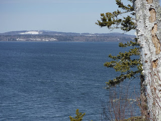
View of the Penobscot River

Deer bed next to a tree

The trails were wide but unmarked

Saturday, February 23, 2019

Witherle Woods in Castine

Today my son and I hiked Witherle Woods in Castine.  It was a balmy 34 degrees and sunny.  We went slightly under 2 miles from the parking lot to Blockhouse Point and then back along the Indian Trail.

In addition to being a beautiful place to hike, the park also has historical significance, as it was used by the British in both the Revolutionary War and the War of 1812. 

We were able to find a spot in the small parking lot.  We had brought snowshoes but found the snow on the trails to be packed down hard so didn't need to use them.

The views from Blockhouse Point and the Indian Trail were beautiful.   The trail down to Blockhouse Point was wide and clear and could be cross-country skied.  The Indian Trail was narrow.  The trails were well-marked, easy to follow and there were frequent maps throughout the park.  They were mostly flat except for a short climb up the Indian Trail.

We also stopped at Dyce Point Lighthouse, the Maine Maritime Academy and the Castine Post Office. (Castine has the oldest continuously operating post office in the United States.  My son is a big fan of the USPS!)

Here is the Witherle Woods Trail Map.

 View from Blockhouse Point
 
 Views from the Indian Trail
 Indian Trail


Trail we took heading to Blockhouse Point

Sunday, February 17, 2019

Wilderness Communication Part 4 - Radios and Other Tools

In addition to cell phones and InReach/Spot satellite devices, there are a few other communication  tools that are useful to have in the wilderness.

We have Motorola Talkabout 35 mile two way radios that we use occasionally.  The 35 mile range would be in open line-of-sight areas (ocean, large lakes, fields, mountaintop to mountaintop).  The actual range is much less, however, these are useful around campsites and when you have a large group hike where the front of the group splits off from the back.  The Talkabout radios have decent battery life and good range, offer a large number of frequencies, are waterproof, and even come with an emergency flashlight.

Two low tech but lightweight, inexpensive and useful tools are whistles and mirrors.  Although GPS and cell phones will get rescuers to your general location, they may be several yards off, which in a heavily forested area could impede rescuers from finding your exact location.  A standard whistle will allow you to signal rescuers with little effort.   Likewise, a small handheld mirror can be used to signal air-based rescue crews as to your location.  Both mirrors and whistles have the added advantage of not requiring battery power to operate.  

Two other devices which we don't have are sat phones and PLB's.  

Satellite phones tend to be expensive to purchase and require expensive plans to use.  The ones that I have used in the past have required an access code followed by the country code and full 10 digit phone number.  In a true emergency entering 16+ digits under stress could be a significant challenge.  

Personal Locator Beacons (PLB's) are one-time use devices that are use to send distress signals.  They typically last 5-7 years on a battery (provided they aren't used).  Most have GPS capability as well as 406 Mhz signalling, which sends a unique signal to rescuers when they are close to your location.   PLB's don't require monthly plans and just require that you register the device.   This site has a nice summary of PLB's: https://www.sarsat.noaa.gov/emerbcns.html.  

Saturday, February 16, 2019

Mt. Battie in Camden Hills State Park

Today my son and I hiked up Mt. Battie along the Mt. Battie Road.  Much of the road was covered in ice, so we used snowshoes the majority of the time.  It was around 34 degrees and sunny.

We climbed the tower at the summit and were rewarded with great views of the coast and surrounding mountains.

It was 3 miles round trip from the lower parking lot to the summit.  It was a decent climb but not overly strenuous.

Park entrance fees were collected ($4 for Maine residents) and facilities (outhouses) were open. 

Here is our trail map.


 Much of Mt. Battie Road was covered with ice and snow.
 Stairs to the top of the summit tower.
 
Views from the tower.

Thursday, February 14, 2019

Snowshoeing Evans Notch, White Mountain National Forest

Today I went on a 3.3 mile snowshoe hike on the closed portion of Route 113 in Evans Notch, White Mountains National Forest.  Around 15-18" of fresh snow fell yesterday and the area was in pristine condition.

The USFS closes Route 113 to vehicle traffic in the winter.  I started from the north end of Route 113 and there was ample space to park near the gate.

There was no sign that anyone had used the section that I hiked on today until I got to Hastings (at which point snowmobile tracks came in from the trail that crosses the bridge at that point).

This was a scenic place to snowshoe as there were views of the river the entire way, along with occasional views of mountains in the distance.  I had hoped to see a moose but no such luck today.

Here is the trail map


Monday, February 11, 2019

Wilderness Communication Part 3 - InReach Satellite Texting

As I noted last week, there are vast sections of Maine that have no cell phone coverage by any provider.  These areas also happen to offer some of the best outdoor recreation opportunities in the state such as Katahdin Woods and Waters, Baxter State Park, the 100 mile wilderness, the Allagash river, Tumbledown Mountain, etc.

InReach devices allow you to use the Iridium Satellite network, which provides coverage worldwide from pole to pole provided you have a clear view of the sky. 

I've been using InReach devices for several years now.  An InReach device allows you to send and receive text messages and notify emergency responders with your location.  They also allow your family and friends to track your location using GPS.  They are rugged IP67 rated devices and can be paired with a smartphone or used independently.

Messages can be sent to cell phone numbers and email addresses.  You can also post to Twitter and Facebook.  You can elect to have your location included with the messages and posts. 

Depending on the model, they are somewhat pricey ($300-400 range) but they are worth it if you spend any amount of time in remote back-country areas.  They also require a monthly plan, which range from around $12/month to $80/month depending on your needs.  I have the $12 plan and usually wind up paying a little extra each month if I go over.

InReach's primary competitor is the Spot X, which I haven't used.  I did briefly have a Spot 2 device, which allowed for one way communication, tracking and emergency notification.  It seemed to work ok but didn't meet my need for two way communication.   The Spot X has added two way messaging.

Three generations of InReach devices.  The 1.5 version on the left lacks a screen. It can
be used independently but requires a smartphone for two way messaging.  The 1.5 version began
having issues lately with its GPS which resulted in the upgrade to the Explorer+ model.  

 Screenshot of the InReach Explorer+.


Sunday, February 10, 2019

Great Pond Mountain Wildlands

Today was a solo 6.2 mile hike in 16 degree temperatures at Great Pond Mountain Wildlands.  It was awesome.

As far as I could tell I was the only person here during the 3 hours I hiked.   I stuck primarily to wider trails, with the exception of the short and icy Red Pine Trail and a brief period of off-trail hiking due to what I assume was a missed trail marker on the Hillside Trail (I used to call this "being lost" but I like my new description better).

Most of the time I was hiking on ice; fortunately I brought microspikes.  There were great views of the surrounding mountains.

Here is a link to the trail map


View of Great Pond Mountain from Valley Road.

Monday, February 4, 2019

Wilderness Communication Part 2 - Cell Phones

Each major cell carrier publishes coverage maps on their websites.   If you look at each carrier's map for Maine, you will notice one thing in common - vast areas without any cell coverage.  Cell companies generally avoid wilderness areas since (1) there are few if any people that live there and (2) it can be costly to maintain towers in remote areas. 

Cell coverage maps represent the best case scenario for each carrier and likely won't reflect the actual coverage that you get with your phone.  Coverage relies on many factors, including terrain and obstructions (i.e. mountains, trees, buildings), your plan (postpaid plans have better coverage than prepaid and will often include roaming), weather, cell towers themselves (if they are down for maintenance) and your equipment.

Equipment plays a big part in your coverage.  Owners of older phones that only have 2g and 3g will find their coverage decrease over time as these networks are phased out and towers converted to 4g and above (for more information research "sunset 2g" and "sunset 3g").  Newer 4g phones have better coverage, but not all 4g phones are created equal.  Different carriers use different frequencies and bands, and as a result, even though a carrier's coverage map will imply they provide coverage for a specific area (for example, I-95 between Orono and Houlton), that coverage may be based on cellular frequencies that your phone can't access.  

Newer unlocked cell phones often have more cell bands than carrier phones.  There are a number of websites that provide cell phone specifications for comparison purposes. 

It is possible to take advantage of low cost prepaid plans to supplement your regular cell plan and create overlapping fields of coverage. Verizon and US Cellular have the broadest coverage throughout Maine, but there are certain areas where AT&T (Acadia) and T-Mobile (Sugarloaf and parts of the Canadian border) have strong coverage.  If you have a few older, unlocked phones, you can purchase cheap plans for supplemental use.  My primary carrier is Verizon, but I also have a $3/mo T-Mobile prepaid number and $10/quarter H2O Wireless (AT&T network).  This has come in handy in Acadia where AT&T has strong coverage and Verizon's coverage is spotty.     

Sunday, February 3, 2019

Papermill Park and the importance of short local hikes

Today's hike was at Papermill Park in Hampden.  Our total distance was less than a mile, and time spent moving was 17 minutes.  It was a great hike, nonetheless, as we had a chance to see great views of the stream and some interesting ice formations.

Sometimes it's easy to dismiss shorter local hikes.  They provide, however, an opportunity to get outdoors and connect with nature on days when you are short on time.  Its also fun to explore places that are less crowded and less popular.

Today's trail map shows that we are in the middle of the stream, so either (1) both my eTrex and cell phone were off or (2) Google Maps isn't 100% accurate for off-road use: Trail map


Saturday, February 2, 2019

Wilderness Communication Part 1 - Introduction to Wilderness Communication

Many people visit the wilderness to escape from society.  Ironically, some of the most important pieces of equipment you can bring are communication gear.  Over the next few weeks I will cover cell phones and other communication gear, but first I want to discuss some things communications gear won't help you with.

1) life threatening emergency medical conditions - if you are bleeding out, having a stroke or heart attack, or suffering from respiratory failure or shock, even with the best communication gear, help can be hours and maybe days away.  Knowing how to perform CPR, apply tourniquets, splint wounds, perform the heimlich, treat heat exhaustion and shock, etc. can save lives.  In extreme weather, even a minor injury can turn into a life threatening situation.

2) exceeding your limitations and the limits of your gear - failing to bring appropriate clothing and other equipment or attempting a strenuous hike without appropriate experience and conditioning cannot be solved by technology.  Rescuers may not help you off a mountain if you are not seriously injured, if they do you may face large rescue bills after the fact, and in some states states (like New Hampshire) you may even face fines. 

3) change the weather - venturing out in extreme weather conditions adds a layer of risk, since rescue teams may not be able to reach you until weather improves.