Sunday, August 30, 2020

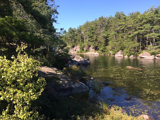
Machias River Corridor Public Reserved Land

The Machias River Corridor Public Reserve Land is part of a collection of lands that protect the 76 mile long Machias River as it flows from Fifth Machias Lake to downtown Machias.  The river is a popular destination for kayakers and canoeists, and the State of Maine operates a number of campsites along the river (see the state's website https://www.maine.gov/dacf/parksearch/PropertyGuides/PDF_GUIDE/machiasriverguide.pdf  for more information.)

My son and I explored the area today as we scouted out potential future camping opportunities.  We visited the Machias RIPS, Log Landing, West Branch and Wonderland Campsites.  We were surprised to find all but the Machias RIPS campsite to be occupied.  Camping here is free but first come, first serve.   CCC Road (the main road leading to the campsites) was a rough washboard road which made travel slow.

First Machias Lake, viewed from Wonderland Campground
Salmon Pond, a short distance from Rt. 9, is a small pond with a boat ramp.

Machias RIPS campground is located directly off Airline Road (Rt 9) and adjacent to the Machias River.


Monday, August 24, 2020

Lagrange to Medford Trail

The Lagrange to Medford Trail is an 11.4 mile gravel and dirt (and rocks) multi-use rail trail that runs past farms, forests and wetlands.  My older son and I cycled the first seven miles from south to north today without seeing a single other person.  The trail was a bit rough in spots and muddy in other spots but generally was a relatively smooth ride.  We wanted to ride further but we concerned by the appearance of storm clouds.  Here is a map of our ride.


Sea Kayaking Class at LL Bean

While I've paddled alot on lakes and flat rivers, I haven't done any ocean kayaking.  It's been a goal of mine to start exploring Maine's coastal islands, so to prepare for that I took an introduction to sea kayaking class at LL Bean this weekend and camped at Bradbury Mountain State Park.

The class was informative and covered kayaking basics such as boat selection and stroke mechanics.   Having been self taught, I picked up many useful techniques to make myself a better kayaker.   The afternoon was spent practicing one and two boat rescues.  The class was small (4 people) and the two instructors were excellent.

Thursday, August 20, 2020

Kayaking to the Phillips Lake Islands

The Great Pond Mountain Conservation Trust holds conservation easements on six islands in the south end of Phillips Lake (see http://www.greatpondtrust.org/barrett-king-easement).  My younger son and I explored the islands by kayak today.

We put in at the public boat ramp at the end of Poplar Road.  From there it was a quick paddle to the islands.  In addition to seeing a number of other kayakers, we also observed bald eagles and numerous fish in the extremely clear water. 

Here is a map of our trip.


Wednesday, August 19, 2020

Stillwater to Sylvan/EMCC Bypass Trail (Bangor)

The City of Bangor built a new paved 0.45 mile trail this year that connects Stillwater Avenue to Sylan Area near Eastern Maine Community College.  The trail allows pedestrians and cyclists to avoid the traffic around the mall area. 

I was off work today watching my dog and was looking for short, paved paths that I could walk him on (he's getting old and has vision problems).  Due to its location immediately next to the Stillwater Avenue Exit off of I-95, the trail lacks a remote feel but was still a pleasant walk.  Here is a map of our walk.


Monday, August 17, 2020

Camden Hills State Park (Ski Shelter Backcountry Glamping & Cameron Mountain)

My younger son and I spent the weekend at Camden Hills State Park.  We arrived Saturday afternoon and hiked two miles to the park's ski shelter.  On Sunday we hiked from the shelter to Cameron Mountain and back.  We hiked down from the shelter Monday morning.  Here is a map of our trip.

Ski Shelter

The shelter is a large one room cabin that contains a wood stove, two picnic tables and four narrow bunk beds.  There is also ample floor space that would allow larger groups to stay overnight. Outside of the shelter is a fire ring, two picnic tables, two stand-alone grills, additional fire wood and a pit toilet.  

The picnic area and toilet get used by park visitors during the day.  In addition, although the shelter door has a lock on it, you aren't given a key and so expect to have people entering when you aren't there to look around.  You can, however, lock the door at night.

The shelter is located in a cell phone dead spot and we had no reception with either Verizon or AT&T. 

There is no potable water at the cabin, however there is a nearby stream and a hand pump across the trail from the shelter that pumps untreated stream water.  The park supplies fire wood both inside and outside the shelter.

The shelter is a replica of a Civilian Conservation Corps cabin that was built here in 1938, used for a period of time, and which then fell into disrepair.  The old cabin was destroyed in 2003 and the rebuilt using the original blueprints in 2005.  The stone floor, foundation and fireplace are from the original cabin.  The cabin can be rented for $50 per night and is insulated for winter use.

We hung around the shelter when we weren't hiking and it gave me an appreciation for a side of Camden Hills State Park that I hadn't seen before.  We saw several runners and bikers go past, and met several local people from the Camden area that stopped in, either to use the toilet, the picnic area or just to chat when they saw us sitting by the campfire.

The shelter is very quiet at night.


Cameron Mountain

On Sunday we set off to hike to Cameron Mountain.  Located in a rear corner of the park, Cameron Mountain gets significantly less visitors than other mountains in the park but it provides 360 degree views from it's bald summit.  We took a loop trail to get there, hiking around 5 miles total from the ski shelter.  


Saturday, August 8, 2020

Kayak Camping, Spectacle Island Preserve (Jefferson)

The Spectacle Island Preserve consists of two small islands in Damariscotta Lake that are owned by the Midcoast Conservancy.  The Conservancy maintains a campsite on each island and for a mere $20/night ($12 for members) both islands can be rented overnight.  The islands offer opportunities for swimming, blueberry picking, exploration and relaxation.  

My younger son and I camped Friday night at the islands.  We arrived late morning and parked at Boat Launch Lane in Jefferson, then kayaked 1/2 mile out to the islands.  

When we first arrived, there were people on the further island so we set up camp on the north island.   The north island has a rope swing and as such appears to get more visitation.  The next time we visit we will camp on the south island instead.  

The island and lake are very scenic and quiet and we noticed very few bugs during our stay.  Swimming was the highlight of the trip.  

Wednesday, August 5, 2020

Baxter State Park Camping Trip

My older son and I spent three nights camping in Baxter State Park this weekend.  Here is a map of our hikes.

Saturday

We arrived at Baxter shortly after 11am and as to be expected for a summer Saturday it was very crowded.  Parking for many day use areas was full.

Our first hike was Sandy Stream Pond and the Roaring Brook Nature Trail.  The  Sandy Stream Pond trail has amazing views of several nearby mountains.  On the way back we decided to do a side trip onto the nature trail.  We were surprised to find large amounts of fresh moose scat on the trail, and while we didn't see any moose, the possibility of spotting one added to our excitement.

For our next hike we did the Daicey Pond Nature Trail and the Little and Big Niagara Falls Trail.  The trails share the same parking lot near the Daicey Pond Campground.  The nature trail circles the perimeter of Daicey Pond and like most lakes in the park has great views of nearby mountains.  The trail to Little and Big Niagara Falls follows the Appalachian Trail to two very beautiful waterfalls.  There were three other groups of people visiting Little Niagara - two families swimming under the falls and a solo fly fisherman fishing nearby.  A short distance further down the trail was Big Niagara Falls, which we had all to ourselves.  The trail led us near the top of the falls.  We hiked a little further and after a little work were able to get out onto some rocks near the base of the falls for better views.  On our way to the falls we briefly spotted a mink running adjacent to the trail.

We finished the day at Nesowadnehunk Field Campground.  The campground is located in a grass field, which allows for excellent views of the mountains. 

Sunday

We woke early and drove to Daicey Pond to watch the sunrise.   We then headed to Kidney Pond to hike the Sentinel Mountain Trail. To access the trail we hiked along Kidney Pond for 0.7 miles, during which we spotted a pair of pileated woodpeckers and enjoyed views of Katahdin and Mount OJI from across the pond.   The Sentinel Mountain trail then splits off and heads away from the pond.  The first section of trail travels up and down through woods.  The trail then begins a relatively steep climb, although no rock scrambling is required.   The trail then emerges at the summit, offering incredible views of the major mountains of Baxter State Park, including Katahdin, The Owl, Mount OJI and Doubletop Mountain.  A moderately challenging loop trail around the summit provides nearly 360 degree views of the surrounding countryside.  This hike was more challenging than we had expected but it was well worth the effort.  

We made our way to South Branch Pond Campground, which would be our home for the next two nights.  The campground sits right on beautiful South Branch Pond in the north section of the park and is surrounded by mountains.  We spent the afternoon relaxing on the lake and recovering from our morning hike.

After dinner we hiked the short (one mile round trip) trail to South Branch Falls.  The stream has worn away a sluice in the rocks producing a small but beautiful waterfall. 

Monday
After watching the sunrise on South Branch Pond, we hiked the Pogy Notch Trail to Upper South Branch Pond.  The trail was relatively flat and easy.  After a brief stop and the.pond, we headed back and stopped by Lower Howe Falls.   These are a series of beautiful falls a short distance off Pogy Notch Trail. 

That afternoon, we rented a canoe and paddled to Upper South Branch Pond.  This required us to drag the canoe through a shallow connecting stream.
We took a drive that evening after dinner and spotted a bull moose walking along the side of the road.  

Tuesday

We left Tuesday morning out the north gate of Baxter and on the way home explored the north end of Katahdin Woods and Waters National Monument