Sunday, June 30, 2019

Hiking in the Rain - Porcupine Watching at Bangor City Forest

I like hiking in the rain. With the right equipment, it's enjoyable and tends to be a lot less crowded.  A good raincoat and waterproof boots help significantly.  

Today I went hiking in the rain at the Bangor City Forest and during the four miles didn't see another person. The mosquitoes were pretty bad but since I had a raincoat and bug netting the only exposed part of my body were my hands, which I had sprayed with bug spray. 

I found a porcupine snacking on some plants near the side of a trail and spent around five minutes watching him from about 5 feet away before he realized that I was there.

Here is a trail map for today's hike. 

This porcupine spent several minutes eating before noticing me.


Here the porcupine is rubbing his eyes.

At one point he shook vigorously and then went back to eating.  
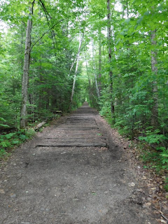
East-West Trail. 
Waterproof boots are essential in wet conditions.
This is a FujiFilm XP120 camera.  I love this camera, as its waterproof to 65 feet deep (you can use it while scuba diving) and shockproof to nearly six feet.  It has 5x optical zoom and several different shooting modes.  I take most of my pictures with this camera. 

Saturday, June 29, 2019

Sanford Trails

Sanford, Maine has an extensive network of scenic trails that run throughout the town.   

For those of you that have been following my blog, you know my son has been training for his first marathon.  Today was the big day, and Mainly Marathons created a 1.88 mile trail using Sanford's trails and some quiet neighborhood streets.

I had the privilege of running with my son for two of his 14 laps towards the end of the race.  One of the great things about the loop system is that the other runners get to know you throughout the race, and it was incredible the amount of support they gave my son as he ran past on his final lap.  Despite being sick with a respiratory virus the final two weeks before the race (including today), he was able to finish strong. 

Mainly Marathons hosts marathons across the country, with the option of multi-day series events.  As this was the last race of a seven day series, there was a strong sense of community among participants.  The marathon was well run and provided runners with excellent support.


For more information on the Sanford trail network, see the town recreation department site.

For more information on Mainly Marathons, see their website.

Trail map of the race from Mainly Marathons' website
The marathon consisted of fourteen laps on a 1.88 loop trail

The route passed Stump Pond

Part of the route used quiet residential streets


Saturday, June 22, 2019

Orono Bog Boardwalk and Bangor City Forest

One advantage of having an outdoor club at work is that it gives people an opportunity to get to know each other outside of work while engaged in a healthy activity.

I went on a 2.7 mile hike at the Orono Bog Boardwalk and Bangor City Forest with my workplace's outdoor club.  We had a good group of people which made for an enjoyable trip, despite the large number of mosquitoes.

We elected to take the East West loop trail to the Bog Boardwalk, and then the Tripp Road to the Deer Trail and back along the Tripp Road.  This provided a nice sampling of the different trail types in the forest.

Here is a trail map of our hike today.  For a full map of the forest, you can visit the official site here.

The bog boardwalk passes through a wooded bog area...

... and continues to an open bog with expansive views of the area.


Sunday, June 16, 2019

Goggins Island, Leeds, Maine

Goggins Island is a small public use area and canoe portage spot along the Androscoggin River in Leeds.  We came across it on our drive back from New Hampshire as we were looking for a place to get out and stretch our legs. 

We hadn't expected much having never heard of this spot but were surprised to find a developed trail system and beaches from which people were fishing.   We hiked around a half mile and felt much better afterwards. 

Here is a trail map


Saturday, June 15, 2019

Hiking and Camping in the White Mountain National Forest (New Hampshire)

I love the White Mountains.  At 750,000+ acres, there is so much to see and explore.  The forest offers miles of hiking trails through diverse environments including dense forests, ponds, alpine mountain peaks, and mountain streams.

My son and I spent two days exploring trails and camping off the Kancamagus Highway (Rt 112). 

Lincoln Woods and Franconia Falls

The Lincoln Woods Trail is flat and wide with a slight incline.  As a former railroad bed, it still has several railroad ties in place.  The trail begins at the Lincoln woods visitor center and heads up into the Pemigewasset Wilderness.  We traveled on the Lincoln Woods Trail for 2.6 miles before reaching the Franconia Falls Trail.  After an additional 0.4 miles, we came to Franconia Falls.  This is a relatively easy hike with little gain in elevation, and we saw a few runners and dog walkers using the trail while we were there.  Here is the trail map.

Note the railroad ties still in place.
Franconia Falls

Franconia Falls
Franconia Falls with mountain view

Lower Falls Scenic Area

The Lower Falls Scenic Area is a parking area with a short walk to an overlook of a falls.  During our last visit here, my kids and I swam under the waterfalls.  Due to the water and air temperatures today no one was swimming.  This is a short easy walk with nice views.


Rocky Gorge Scenic Area

The Rocky Gorge Scenic Area is another short, paved handicapped-accessible trail.   It leads to beautiful views of Rocky Gorge, a narrow gorge with a waterfall.  Here is a trail map.

View of the falls from the rocks

There is a bridge spanning the gorge
View of the gorge from the bridge
Covered Bridge Campground

The Covered Bridge Campground is one of several Forest Service campgrounds off of the Kancamagus Highway.  It's a fairly straightforward campground, offering a picnic table, fire ring, and flat piece of ground to put a tent on.  There were relatively clean pit toilets located at various points throughout the campground and a water spigot.  There are no showers located in this campground; however there are showers at the Jigger Johnson campground 6.5 miles away.

Our camping experience was marred by an abundance of mosquitoes, a neighbor that greatly enjoyed 80's rock well into the night, and the proximity of the campground to the highway (this probably isn't usually an issue, but our trip coincided with Laconia Bike Week and therefore several groups of bikers were driving through the area).

Its worth noting that we had no cell phone coverage with Verizon, AT&T or T-Mobile throughout most of the Kancamagus Highway, with the exception of a few limited spots of Verizon and AT&T coverage by a few of the overlooks.  We relied heavily on the InReach to communicate with the outside world.  

There was also a picnic table, not shown. 


Sunrise at the Sugar Hill Overlook

Sugar Hill Overlook is a short distance from the Covered Bridge Campground and provides nice views of several of the mountains in the area.  We took advantage of this by getting up at 4:30am to take pictures of the sunrise. 


Sabbaday Falls

Sabbaday Falls is a 40 foot waterfall which can be reached via a 0.7 mile (round trip distance) trail.  There is a nice overlook platform from which to view the falls.  Here is the trail map.


Champney Falls Trail

The final hike of our White Mountain trip was Champney Falls.  This turned out to be an incredible hike, with views of both Champney Falls and its neighbor Pitcher Falls.  The water levels were sufficient to allow the falls to be flowing and yet low enough to cross over the stream into the gorge under Pitcher Falls.

The round trip distance was approximately 3.5 miles.  Here is the trail map.  Note that there were an abundance of mosquitoes, so bug spray and mosquito netting is definitely recommended this time of year. 

There is the option to continue on the trail to the summit of Mount Chocorua, for a total roundtrip distance of 7.8 miles.  We chose not to do so on this trip but will likely return in the future.

Champney Falls
Pitcher Falls
Pitcher Falls and its gorge.  For perspective, my 6'3" son is visible in the middle left of the picture.


Thursday, June 13, 2019

Biking Vermont: Stowe Recreation Path and Island Line Rail Trail (Vermont)

We spent the day exploring two of Vermont's nicest bike trails - the Stowe Recreation Path and the Island Line Rail Trail north of Burlington.  We finished our day with short walk in Waterbury.

The Stowe Recreation Path is approximately 5.3 miles long and runs through Stowe and the surrounding area.  It is flat and paved and features nice views of mountains and streams.  The first two miles travels through the town of Stowe, after which it heads out into the countryside past farms and fields.  Here is a trail map.


The Island Line Rail Trail follows an old railroad line north of Burlington, offering great views of Lake Champlain, the Adirondacks in New York, and the mountains of Vermont.  The trail is 14 miles long and starts south of Waterfront Park in Burlington.  It is flat and the first part is paved, later turning to a dirt path and finally a crushed stone path as it heads across a lengthy causeway.  There is an option to take a bike ferry to finish the trail as well as complete a longer loop on the New York side of the lake.

We started at Waterfront Park and rode 10.1 miles north to the bike ferry.  The trail rides along the shore of Lake Champlain, past residential neighborhoods, through a nature preserve and across most of the causeway before coming to an end near the north end of the causeway at the ferry dock.  Here is a trail map.   We encountered strong headwinds leaving the causeway and rode in the rain for the final 5 miles, but it was still an excellent ride.


After riding 31 miles today, we finished our day with a short, yet very rewarding walk.  (Trail map here).

Wednesday, June 12, 2019

Cabin Camping, Little River State Park (Vermont)

Little River State Park is located near Waterbury, Vermont and a short drive from both Stowe and Burlington.   It is on a large lake and offers boat rentals, boat ramps, a beach, and miles of trails.  The park is located where a town once stood before it was flooded in the 1930's.  There are still some structures from that time period in the park. 

The park has a number of campsites as well as cabin rentals.  We rented a cabin and we're glad we did.  The cabin was clean and had a bunk bed (with mattresses) and a futon which folded out into a queen size bed.  The cabin also had a small table with two chairs, a light and four electrical outlets, a smoke detector and fire extinguisher, and a combination lock for the front door.  Outside it had a covered porch with picnic table and a fire pit.  There was also a 30 amp RV outlet.  We brought our own sheets, pillows and sleeping bags. 

Our cabin was conveniently located near park restrooms and showers.  These were very clean, fully functional bathrooms.  The showers were coin operated (quarters only) and also clean.  We observed park staff cleaning the facilities while we were there.

We stayed two nights at the cabin and were very pleased.  The park was quiet and despite other nearby sites being occupied, we barely heard our neighbors.  We also didn't notice any mosquitoes while we were there.

Due to weather and time contraints, we didn't have the opportunity to hike, swim or rent boats while here.  We did go for a short walk out to the Waterbury Dam one night (trail map here).

Outside view of cabin.

The park supplies sheets; however, they were in rough shape.  The mattresses themselves were in good condition.  The futon folds out into a queen sized bed. 

Another view of the inside of the cabin.

I don't usually take pictures of bathrooms, but this was the nicest campground bathroom I've ever seen. 

View from the Waterbury Dam.
Walkway on the Waterbury Dam.