The total round-trip distance, including the summit trail and an overlook spur, equaled slightly more than 3 miles. Here is a map of my hike.
Saturday, October 26, 2019
Great Pond Mountain (Orland)
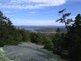
I hiked solo this morning up Great Pond Mountain in Orland. This is a moderate hike with several incredible open views on the way up. There is ample parking at the trailhead and the trail is well marked with trail markers and occasional signs along the route. The trail is well defined although this time of year it was covered with leaves on the lower forested half.
The total round-trip distance, including the summit trail and an overlook spur, equaled slightly more than 3 miles. Here is a map of my hike.
Sunday, October 20, 2019
Tunk Mountain Loop Trail
The last time I visited Tunk Mountain in March, ice on the trail prevented me from ascending once I reached the base. Today I returned to Tunk Mountain with a good group of friends and completed the 4.1 mile loop trail up and over the summit.
The initial one mile of trail is relatively flat, after which it begins a steep ascent to the summit. There are a few locations where rock scrambling is necessary and one area requiring climbing up three rungs. The views from the summit (as well as several overlooks on the way up) were well worth the effort as we all enjoyed the changing fall colors.
We elected to descend the loop trail rather than retracing our steps down the ridge trail. We had read about the challenges associated with this route on AllTrails but decided it would offer a less steep descent in addition to variety. The descent added variety and a great deal of unintended adventure as the trail is poorly marked and poorly maintained. Without the AllTrails app we would have likely gotten lost and even with the app we found ourselves often straying off trail and having bushwhack to get back on.
Overall this was a challenging but enjoyable hike. Here is a map of our hike.
![]() |
View of Tunk Mountain from across Mud Pond |
![]() |
The loop trail after the summit |
Saturday, October 19, 2019
Moose Point State Park (Searsport)
Moose Point State Park is a small coastal state park located in Searsport. There are around two miles of trails in the park but the primary attraction is the beautiful waterfront setting. I visited the park today and hiked 1.4 miles around the perimeter of the park enjoying the views of Penobscot Bay. The park closes for the season at the beginning of October but they allow visitors year round (although park facilities are closed and the entrance road is gated.) The park also has a small beach, playground and picnic area, and gazebo and group shelter for events.
Here is a map of my hike.
Monday, October 14, 2019
Spring Point Ledge Lighthouse
My son and I visited Spring Point Lighthouse this morning while in South Portland. It is a short 0.6 mile round trip from the parking lot to the tip of the lighthouse jetty (here is a map). The park, located on the grounds of Southern Maine Community College, has great views of Casco Bay and its islands and also provides access to the batteries and other fortifications of Fort Preble.
The jetty out to Spring Point Lighthouse. |
View of Fort Gorges in Casco Bay |
Fort Preble |
The lighthouse, which was closed today, is open for tours during the annual lighthouse day event. |
When my kids were little, the jetty used to terrify me with the prospect of them falling between the large rocks. Fortunately that never happened. Today's trip was much less terrifying. |
Sunday, October 13, 2019
Hedgehog and Bradbury Mountains (Freeport and Pownal)
My son and I visited Hedgehog and Bradbury Mountains today, and camped overnight at Bradbury Mountain State Park.
Hedgehog Mountain is managed by the Town of Freeport. There are around five miles of trails in the park including a short trail to the summit. This is more of a hill than a mountain (the town brochure puts the word mountain in quotes and almost apologetically states that it's the highest point in Freeport).
![]() |
View from the summit of Hedgehog |
When we lived in the Portland area, we frequently hiked at Bradbury Mountain State Park, and were happy to return to the park today. There are several trails throughout the park including several open to mountain bikes. The mountain itself has an open summit with great views of the surrounding countryside.
![]() |
View from Bradbury Mountain |
The park is open to camping year round. The park has showers and a small kitchen area with a microwave oven and sink for washing dishes.
![]() |
Kitchen area at Bradbury's campground |
Sunday, October 6, 2019
Mount Waldo (Frankfort) revisited
A week ago when I first visited Mt. Waldo, it's summit was covered in fog. We returned today and were treated to excellent views of the surrounding countryside. Here is a map of our hike.
![]() |
Evidently there is another way up the mountain since this truck was at the summit working on the cell tower. |
Saturday, October 5, 2019
Camden Hills State Park (ski shelter trail/slope trail/Mt Megunticook
My son and I hiked at Camden Hills State Park today, taking advantage of the beautiful fall weather. We started out on the ski shelter trail, which is essentially a dirt road with some elevation gain. We hiked two miles to the ski shelter where we stopped and enjoyed our lunch. We then headed up the slope trail to the forested summit of Mt Megunticook. On the way down we stopped at the Ocean Lookout and enjoyed incredible views of the surrounding area including Camden, Ragged Mountain and Penobscot Bay.
Here is a map of our hike.
![]() |
View from Ocean Lookout |
![]() |
Ocean Lookout |
![]() |
Oddly, it wasn't this crowded when we were up here in March. |
![]() |
Trail across the summit of Mt. Megunticook |
![]() |
The wooded summit of Mt. Megunticook |
![]() |
The ski shelter is available for rent. |
![]() |
Ski shelter trail. |
![]() |
Fall colors. |
Subscribe to:
Posts (Atom)